
One of the most frequent questions we receive at Nordic Riders is: “Which scenic roads best match my experience level?” Whether you are a seasoned tourer or planning your first Scandinavian adventure, we’ve created this ranking to help you choose the right Norwegian Scenic Routes to include in your motorcycle adventure.
For those who have not yet heard of them, Norwegian Scenic Routes are 18 roads selected by Norway to showcase its landscapes with unique natural qualities, along coasts and fjords, mountains and waterfalls.
We also hope this list serves as a guide for selecting the right bike. While there are countries where heavy adventure bikes make perfect sense, Norway is rarely one of them. As you will read, our roads are narrow and incredibly curvy. We have low speed limits, and you truly do not need a powerful bike for overtakes; Norwegian drivers are remarkably courteous and will often actively help you pass, knowing you’ll enjoy the view better from in front of their car.
For the kind of touring done in the Nordics, we consistently recommend mid-size adventure bikes. Riders returning from the fjords time and again confirm that a lighter, more flickable machine was the right choice. Alternatively, mid-size cruisers are a fantastic option for a more relaxed rhythm, especially on the routes in our first two categories.
Level 1: The Gentle Cruisers
Wide lanes and minimal elevation. Ideal for cruisers and relaxed sightseeing.
1. Jæren
The easiest ride in the country. It follows the North Sea coastline through flat, open cultural landscapes. No hairpins—just long horizons and sea air.
- Location: South-West (Hå to Klepp)
- Length: 130 km | Elevation: 0 – 274 masl
- GPS: 58.5273, 5.6148
2. Atlanterhavsvegen (The Atlantic Road)

Visually iconic but technically simple. The road is wide and well-paved. The only “difficulty” is the wind hitting you on the high bridges.
- Location: West (Kårvåg to Bud)
- Length: 36 km | Elevation: 0 – 30 masl
- GPS: 63.0166, 7.3541
3. Varanger
A ride to the edge of the Arctic Ocean. The road is mostly flat and straight, though you must watch for sheep and reindeer on the tarmac.
- Location: Far North (Varangerbotn to Hamningberg)
- Length: 160 km | Elevation: 0 – 123 masl
- GPS: 70.1705, 28.5744
4. Andøya

Features long, flat stretches along the outer coast. Very little technical maneuvering, allowing you to focus entirely on the whale-watching potential.
- Location: North (Andenes to Bjørnskinn)
- Length: 58 km | Elevation: 0 – 65 masl
- GPS: 69.3144, 16.1204
Level 2: The Moderate Sweepers
Consistent curves and moderate climbs. Requires focus but offers plenty of road width.
5. Helgelandskysten
The longest route. The riding is mostly easy coastal curves, but the six ferry crossings and total distance require good logistical planning.
- Location: North (Holm to Bodø)
- Length: 433 km | Elevation: 0 – 346 masl
- GPS: 65.8561, 12.4705
6. Rondane (Personal Favorite)

This is one of our absolute favorites. It might not be as “epic” or “thrilling” as Trollstigen, but riding through this ancient landscape somehow evokes the true spirit of a classic motorcycle journey. It’s soulful, flowing, and pure joy.
- Location: East (Venabygdsfjellet to Folldal)
- Length: 75 km | Elevation: 700 – 1060 masl
- GPS: 61.8546, 9.8324
7. Valdresflye
A mountain plateau with “endless” views. The road is wide with great visibility, though you are very high up and exposed to the elements.
- Location: East (Garli to Vågå)
- Length: 49 km | Elevation: 890 – 1389 masl
- GPS: 61.3663, 8.8172
8. Havøysund
A winding road through a barren, rocky moonscape. It has more lean-angle opportunities than other northern routes but stays wide enough for comfort.
- Location: Far North (Kokelv to Havøysund)
- Length: 67 km | Elevation: 0 – 233 masl
- GPS: 70.9963, 24.6622
Level 3: The Technical Ascents
Narrowing lanes and significant elevation. These routes test your low-speed balance.
9. Lofoten

Technically “moderate” in design, but the traffic jams in July are a real factor. Navigating narrow bridges and dodging rental campers requires constant vigilance.
- Location: North (Å to Fiskebøl)
- Length: 230 km | Elevation: 0 – 59 masl
- GPS: 68.1211, 13.5042
10. Sognefjellet
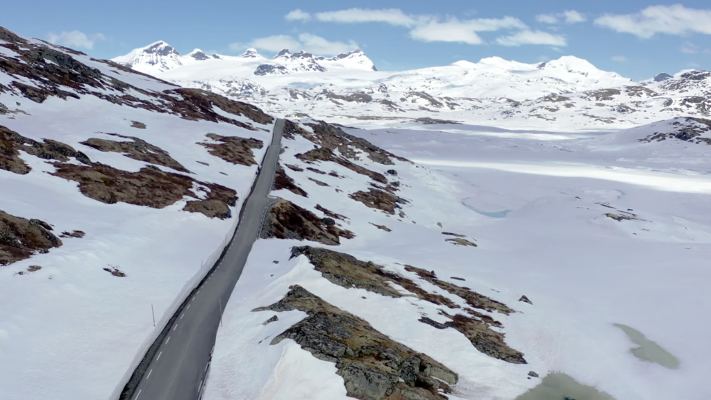
The highest pass in Northern Europe. Expect steep gradients and sweeping hairpins. Even in July, you might be riding between walls of snow.
- Location: West (Lom to Gaupne)
- Length: 108 km | Elevation: 0 – 1434 masl
- GPS: 61.5583, 7.9947
11. Hardanger
Famous for fruit orchards and fjords. The challenge here is the narrowness; you’ll often find yourself sharing tight fjord-side tarmac with large tour buses.
- Location: West (Halne to Steinsdalsfossen)
- Length: 158 km | Elevation: 0 – 1250 masl
- GPS: 60.3681, 6.1436
12. Ryfylke
Includes the rugged Saudafjellet pass. It’s narrow, remote, and requires precise throttle control through tight, rocky sections.
- Location: South-West (Oanes to Håra)
- Length: 260 km | Elevation: 0 – 972 masl
- GPS: 59.4125, 6.2589
13. Senja
Features the steep Bergsbotn hairpins. The road is incredibly scenic but has high exposure (steep drops) and sharp turns.
- Location: North (Gryllefjord to Botnhamn)
- Length: 102 km | Elevation: 0 – 287 masl
- GPS: 69.4444, 17.2941
4. Hardangervidda
A massive plateau. The difficulty here isn’t the turns, but the physical endurance required to handle high-speed winds on a motorcycle for 67 km.
- Location: West (Eidfjord to Haugastøl)
- Length: 67 km | Elevation: 0 – 1250 masl
- GPS: 60.4194, 7.3742
Level 4: The Expert Hairpins
The most demanding roads. Expect 10% gradients, gravel, and extreme hairpins.
15. Geiranger – Trollstigen

The ultimate technical test. Trollstigen has 11 hairpins at a 10% grade. In July, you must also account for traffic jams—stopping and starting a heavy bike on a steep hairpin while waiting for a bus to pass is an expert-level move.
- Location: West (Langevatn to Åndalsnes)
- Length: 104 km | Elevation: 0 – 1038 masl
- GPS: 62.4542, 7.6661
16. Aurlandsfjellet (The Snow Road)
The high-altitude alternative to the Lærdal Tunnel. It is often a single lane with passing pockets and features sharp, blind mountain corners.
- Location: West (Aurlandsvangen to Lærdalsøyri)
- Length: 47 km | Elevation: 0 – 1308 masl
- GPS: 60.9856, 7.3114
17. Gaularfjellet
A series of 9 hairpins that wind up from the fjord. It’s quieter than Trollstigen but equally technical, requiring smooth clutch and brake work.
- Location: West (Balestrand to Moskog)
- Length: 114 km | Elevation: 0 – 784 masl
- GPS: 61.3417, 6.5414
18. Gamle Strynefjellsvegen

Not the most twisty, but the most challenging for heavy touring bikes. This historic road is partially unpaved gravel. The combination of loose surfaces and narrow width makes it a true adventure.
- Location: West (Videsæter to Grotli)
- Length: 27 km | Elevation: 465 – 1139 masl
- GPS: 61.9482, 7.4258
Ready to select the bike to tackle these routes with? We offer rentals that include unlimited mileage, pannier, phone holder, and even full insurance. Plus, for adventures 10 day advantures and longer, you get 10% off the standard daily rate.
Disclaimer: We helped ourselves with some AI photo editing for this article as we wanted to show you very specific parts of some of the roads, which would have been impossible to obtain during the winter when the article was being put together.
Take Care Until The Next Time
Your Nordic Riders

